
Inkster Neighbors by Block
A block inquiry has several distinct layers. Wayne County GIS is the starting place for parcel geometry and nearby streets. Inkster’s BSA assessment route can connect a selected parcel to owner and tax-property information, subject to the city’s current-data warning. The Register of Deeds adds a selected parcel’s recorded transfer trail. The city’s block-club table supplies meeting information for local civic groups, not membership records. These sources help orient a person to a block without creating a list of households.
| Source | What It Shows About a Block | Access |
|---|---|---|
| Wayne County GIS | Parcel shapes, roads, nearby parcels, parks, and boundaries | Public interactive viewer; live pop-up fields are dynamic |
| Inkster BSA | Selected parcel owner and tax-property context | Address, name, or parcel route; exact live card fields need verification |
| Wayne Register of Deeds | Recorded instruments and transfer parties for a selected parcel | Free name index; expanded search or images may need payment or office access |
| Inkster block clubs | Published civic groups, meetings, and venues | Official city table, not a roster |
| Michigan voter tools | Person-centered registration status and lawful file routes | Public lookup or scoped MDOS request; protected fields withheld |
Ownership and occupancy are not the same. An owner mailing address can be elsewhere, a title can be held by a trust or entity, and a parcel card does not identify every person at the location. For Inkster neighbors, use property evidence as a parcel fact and confirm any separate personal question through the proper custodian.
Keep a short record log for each selected parcel: the address searched, parcel identifier, legal description when shown, source URL, and search date. A legal description is the lot, subdivision, or boundary language that identifies the land; it can remain useful when a street label changes. The map supplies block geometry, BSA supplies a property record, and a deed can establish a transfer date. Those observations should remain separate rather than being compressed into a claim that someone currently lives on the block.
Mapping Inkster Neighbors by Parcel
The county’s official map guidance confirms zoom, pan, parcel selection, and layers for parcels, roads, parks, and boundaries. Start at the subject address in the Wayne County Parcel Viewer, then work outward at parcel scale. The live viewer did not expose a stable inventory of pop-up fields during research, so do not assume a field is available until it appears in the current tool. Preserve the parcel identifier and the map date before opening any related record.
- Search or pan to the Inkster address, then zoom until parcel boundaries and street frontage are visible.
- Select the subject parcel and note its identifier, visible shape, and the streets or alleys that define its edge.
- Select each parcel sharing a boundary or fronting the same short block, then record the parcel identifiers without assuming a household relationship.
- Use BSA for the selected parcel’s owner context and the Register of Deeds for a documented transfer, keeping mailing and situs addresses distinct.
The process is address to parcel, parcel to recorded owner context, then record-by-record verification. A line on the map can be interrupted by an alley, corner lot, condominium boundary, drainage feature, or public right-of-way. Adjacent polygons are a spatial relationship, not a statement about who knows, visits, or lives with whom.
A full named-street record chain belongs on the Inkster by-street directory. The tighter method here stays with the few parcels immediately around one address.
Note: Check both parcel shape and visible frontage before calling two locations adjacent, especially where a corner, alley, or right-of-way changes the block relationship.
Inkster Block Edges and Wards
Inkster has a six-district ward framework. Its district descriptions use major streets including Michigan Avenue, Cherry Hill, Annapolis, Avondale, Beech Daly, Eastern, Princess, Harrison, and Henry Ruff. Those streets are useful orientation points when a block crosses a civic boundary or when a request needs a ward and precinct reference. They are not a substitute for the legal boundary description or a reason to infer a person’s district from a nearby street alone.
Map scale also matters. Two homes with similar postal descriptions can face different streets, fall on opposite sides of a right-of-way, or connect to different civic districts. Compare the selected parcel’s actual frontage and legal description with the city’s ward boundary material. The same care helps when a historical record uses an older township or street name.
Note: Ward streets help organize a public request, but they do not turn a map view into a list of private people.
Inkster Block Clubs Meet Here
The city’s Block Clubs and Neighborhood Watch Groups listing adds a civic layer that a parcel map cannot provide. It publishes the group name and meeting pattern, while leaving contact details on the official source rather than repeating personal details elsewhere. Several gatherings use Booker T. Dozier Recreation Complex at 2025 Middlebelt Road. The Community Policing Office number listed by the city is 734-326-3834. These contacts are for neighborhood participation, not a way to obtain a membership list.
| Block club or association | Published meeting pattern | Location note |
|---|---|---|
| Crescent Circle Block Club | Second Thursday, 7 p.m. | Use the city listing for the current contact. |
| Middle Park Manor Block Club | Second Monday, 6 p.m. | Recreation Complex. |
| Princeton Street Block Club | Second Saturday, 5 p.m. | Use the city listing for the current contact. |
| Inkster Central | First Thursday, 6:30 p.m. | Recreation Complex. |
| Southwest | Tuesdays, 6 p.m. | Beech Daly and Harrison area note. |
| Watsonia Park Block Association | Second Tuesday, 6 p.m. | Use the city listing for the current contact. |
Inkster’s block-club table is shown here as the official source for neighbors seeking a civic meeting rather than private contact information.
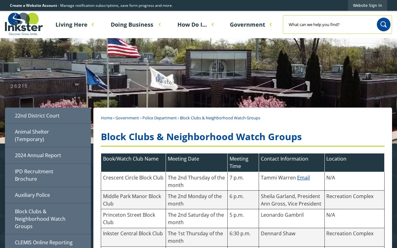
The table connects neighbors through published meetings and city contacts, while respecting that it does not identify members or households.
Inkster Neighbors and Voter Files
Michigan’s public voter lookup is person-centered. It can help an individual check registration status, local clerk, polling place, ballot, and election information. It is not a public block-by-block browse. The Michigan Qualified Voter File has a statewide street-address index under MCL 168.509p, yet that does not make a neighborhood list an appropriate output for a neighbors search.
A QVF FOIA request is limited to one chosen geography, such as a city or township, district, or one ward and precinct combination. It requires requester contact and signature, and it offers pickup, FTP, or mail delivery. Public data may include a name, residence or available mailing address, birth year, registration date, voter status, history, and district codes. Phone, email, full birth date, driver-license or state-ID number, signature, and the last four Social Security digits are excluded. Voter history shows participation, not ballot selections.
Use aggregate district or precinct information for civic context. Do not publish names from a scoped file, and do not attempt to reverse-engineer a protected voter or Address Confidentiality Program participant.
Official Records for Inkster Neighbors
Official systems identify their keeper, date, and access boundary. Compiled neighbor tools combine public filings, marketing material, old addresses, and relationship guesses. Their profiles may be stale, merge people with similar names, repeat one source several times, or omit protected people. The difference matters most when an address has changed hands, a unit has several occupants, or the inquiry involves a person who should not be exposed.
| Official record category | Compiled neighbor category | Practical limit |
|---|---|---|
| GIS parcel map | Map and relationship profile | GIS shows geometry, not a social connection. |
| Assessment or deed record | Address history profile | Recorded ownership is not proof of present occupancy. |
| Voter status route | Person-list profile | Statutory protections and purpose limits still apply. |
| City block-club table | Community contact profile | Meeting information is not a member roster. |
For Inkster neighbors, retain the official source URL and search date. If a compiled result conflicts with an official parcel, court, or city record, ask the relevant custodian about the underlying official record rather than repeating the compiled claim.
Note: A dated official record answers a narrower question more reliably than a broad profile assembled from older sources.
Inkster Neighbors Beyond Maps
Selected parcels may have other address-keyed records, but their access varies. The city has building, planning, permit, and code-enforcement routes. No public searchable code-case index was located. A narrow request can name an address and date range, then ask for permit number, work description, applicant or owner fields, inspection dates, disposition, and available copies. Utility customer records are not public evidence of who lives at an address.
For a prior property transfer, use the Register of Deeds as a record trail, not a present-neighbor list. The county’s online search has a free name route, and expanded address, legal-description, parcel, tax-ID, or image access may require a paid route or office help. A conveyance should also be distinguished from a mortgage, lien, release, or correction.
Inkster Neighbor Privacy Limits
Public parcel data cannot identify every non-owner occupant or household member. Other protected groups include Safe at Home participants, protected voters, sealed court parties, utility customers, delivery recipients, and unlisted subscribers. The Michigan Address Confidentiality Program under Act 301 of 2020 supplies qualifying participants with a substitute address and mail forwarding. Government entities use the designated address when one is required.
Do not reconstruct a protected physical address from a mailing detail, map, voter field, court document, or a combination of records. An empty result is not proof that nobody lives at a property, and an owner result is not a statement about everyone at the address. Ask a custodian to correct a record with the record identifier and documentary proof when an official entry is wrong.
Lawful use. Use Inkster neighbors research for civic participation, reconnecting, family history, property curiosity, or personal safety awareness. Never use an address or record to stalk, harass, intimidate, or harm anyone.